13 Solved Questions with Answers
-
2024
What is disaster resilience? How is it determined? Describe various elements of a resilience framework. Also, mention the global targets of Sendai Framework for Disaster Risk Reduction (2020-2030). (Answer in 250 words)
Approach:
- Introduction: Define disaster resilience
- Body:
- Mention factors determining Disaster resilience along with elements of a resilience framework.
- Mention 7 Global Targets Of Sendai Framework For Disaster Risk Reduction (2015-2030) along with Priorities for Action.
- Conclusion: Give the Government of India’s initiative to implement the Sendai Framework.
Introduction:
Disaster resilience is the ability to withstand, prevent, and recover from the harmful effects of natural hazards on people, places, and the environment.
Body:
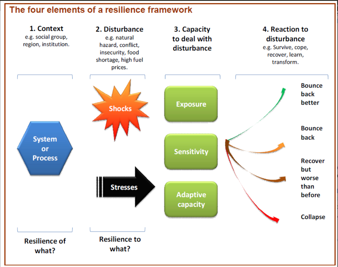
Disaster resilience is determined by several factors, including:
- Adaptive capacity: The ability to adjust to disturbances, moderate damage, and learn from shocks.
- Exposure to risk: The magnitude and frequency of shocks or stress.
- Sensitivity: How much a system is affected by a shock or stress.
- Organisation: The ability to organize oneself to learn from past disasters and reduce future risks.
Four Elements of Resilience Framework:
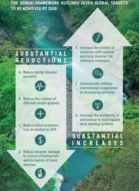
Global Targets of Sendai Framework For Disaster Risk Reduction (2015-2030):
The Sendai Framework for Disaster Risk Reduction is a UN General Assembly-endorsed agreement that aims to reduce disaster risk and losses through a combination of global targets and a shared responsibility between governments and other stakeholders.
Priorities for Action:
- Priority 1: Disaster risk management needs to be based on an understanding of disaster risk in all its dimensions of vulnerability, capacity, exposure of persons and assets, hazard characteristics, and the environment.
- Priority 2: Disaster risk governance at the national, regional, and global levels is vital to the management of disaster risk reduction in all sectors.
- Priority 3: Public and private investment in disaster risk prevention and reduction through structural and non-structural measures are essential to enhance the economic, social, health and cultural resilience of persons, communities, countries and their assets, as well as the environment.
- Priority 4: Enhancing disaster preparedness for effective response, and to Build Back Better in recovery, rehabilitation, and reconstruction.
Conclusion:
The Government of India has issued a set of priority actions based on the goals, targets, and priorities of the Sendai Framework 2015-2030. The government of India, during the Asian Ministerial Conference for Disaster Risk Reduction (AMCDRR) 2016, has extended the grant of USD 1 million to UNISDR for the effective implementation of the Sendai Framework for Disaster Risk Reduction in the Asian region.
-
2024
Flooding in urban areas is an emerging climate-induced disaster. Discuss the causes of this disaster. Mention the features of two such major floods in the last two decades in India. Describe the policies and frameworks in India that aim at tackling such floods. (Answer in 250 words)
Approach
- Start the answer by defining urban flooding.
- Discuss key contributors to urban flooding. Highlight significant flood events, noting their causes. Highlight policies and frameworks related to flood management.
- Conclude by emphasising the importance of effective management and sustainable infrastructure to enhance urban resilience against flooding.
Introduction
Urban flooding, a climate-induced disaster, occurs when heavy rainfall overwhelms drainage systems, inundating land or property in densely populated areas like cities.
Body
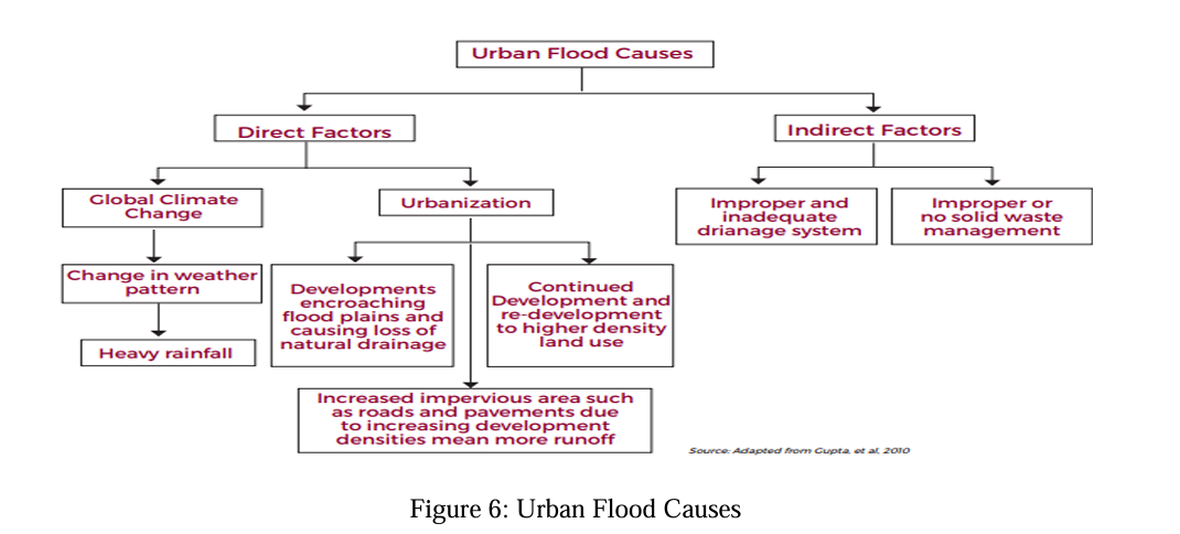
Causes of Urban Flooding:
- Climate change: Drives urban flooding by increasing rainfall intensity. Warmer air holds more moisture, resulting in heavier precipitation. Rising temperatures, particularly in urban heat islands, further disrupt seasonal weather patterns.
- Sea-level rise heightens risks for coastal cities, leading to flooding and freshwater contamination.
- Urbanisation: Exacerbates flood risks by increasing impervious surfaces that elevate runoff and reduce water absorption, while encroachments on floodplains disrupt natural water flow due to inadequate regulations.
- Improper Solid Waste Management: Blocks drainage systems, causing overflow during heavy rains and further complicating flooding risks with the mixing of sewage and stormwater.
Major Flood Events:
- Chennai Floods (2015): Heavy rains and poor drainage, along with the destruction of 300 inland water bodies due to urban growth, intensified flooding. Significant reduction of Pallikaranai marshlands undermined natural ecosystems and flood control.
- Mumbai Floods (2005): Triggered by heavy rainfall, overwhelming a century-old drainage system designed to handle only 25 mm of rain per hour. Urbanisation led to a 40% reduction in mangroves and decline in green spaces, further aggravating flooding and preventing effective water absorption.
Policies and Frameworks to Tackle Urban Floods in India
- Guidelines on Management of Urban Flooding (2010): Issued by National Disaster Management Authority, these guidelines promote a multi-disciplinary approach for urban flood management planning.
- Smart Cities Mission (2015): Promotes sustainable urban infrastructure, including smart drainage and flood management systems.
- AMRUT 2.0: Focuses on upgrading stormwater drainage and urban infrastructure to reduce flood vulnerability.
- Storm Water Drainage Manual (2019): Provides guidance on sustainable stormwater management and flood response planning.
Conclusion
Urban flooding driven by climate change poses significant risks to cities. Effective management through sustainable infrastructure and adherence to NDMA guidelines can enhance city resilience.
-
2023
Dam failures are always catastrophic, especially on the downstream side, resulting in a colossal loss of life and property. Analyze the various causes of dam failures. Give two examples of large dam failures.
A dam failure is simply an uncontrolled release of water from a reservoir through a dam because of structural failures or deficiencies in the dam. Ranked third in terms of building large dams, dam failure in India can potentially result in a release of large quantities of water imposing risks on the people or property downstream.
Causes of dam failures
- Overtopping: It is caused due to poor spillway design, leading to a reservoir filling too high, especially in times of heavy rainfall.
- Foundational Defects: Instability of slopes can lead to seepage of water beneath the dam.
- Operational Failures: Valves and conduit failures often cause improper functioning which can lead to inadequate water discharge.
- Geological Instability: Tectonic induced calamities like landslides, earthquakes can pose a threat to dam structures.
- Ageing Dams: Rising frequency of flooding and other environmental changes can accelerate the dam’s ageing process.
- Structural Failure: Inadequate design, construction materials, or maintenance can lead to dam collapse.
Examples of large dam failures
- Machchu II Dam Failure (1979): Due to heavy rainfall and improper design, the Machchu II Dam in Gujarat burst, resulting in a catastrophic flood. The torrential flow destroyed villages, claiming the lives of over 2,000 people.
- Tiware Dam Failure (2019): Situated in Ratnagiri, Maharashtra, the Tiware dam breached due to excessive rainfall, flooding seven villages and killing several people.
Efforts like the Dam Safety Act 2021 and Dam Rehabilitation and Improvement Project (DRIP) are the steps in right direction to prevent catastrophic events of dam failure in India.
-
2022
Explain the mechanism and occurrence of cloudburst in the context of the Indian subcontinent. Discuss two recent examples.
Cloudbursts are short-duration, intense rainfall events over a small area. According to India Meteorological Department (IMD), it is a weather phenomenon with unexpected precipitation exceeding 100mm/h over a geographical region of approximately 20-30 square km. In the Indian Subcontinent, it is generally observed in the Himalayan region.
Mechanism of cloudburst
When moisture laden air moves the hilly terrain, it forms vertical column of cloud also known as cumulonimbus cloud. These clouds are generally associated with rain, thunder and lightning. These unstable clouds cause an intense rainstorm over a small area and locked in the ridges and valleys between the hills.
Occurrence of cloudburst
The relative humidity and cloud cover is at the maximum level with low temperature and slow winds because of which clouds may get condensed at a very rapid rate and result in a cloudburst.
Recent incidents
- Amarnath Cloudburst in July 2022, which caused heavy casualties of pilgrims on yatra.
- In August 2022, several people have been killed in destruction caused by cloudbursts and flash floods in different parts of Himachal Pradesh and Uttarakhand.
With rising occurrences of cloudburst every year, it has become necessary to install dense network of weather instruments, and computing capabilities especially for hilly regions.
-
2021
Discuss about the vulnerability of India to earthquake related hazards. Give examples including the salient features of major disasters caused by earthquakes in different parts of India during the last three decades.
An earthquake is the shaking of the earth caused due to the release of energy which generates waves that travel in all directions. Earthquake hazards can range across ground shaking, surface rupture, landslide, liquefaction, tectonic deformation, tsunami etc.
India is prone to earthquakes because:
- The landmass is penetrating into the Eurasian plate, which makes the country prone to earthquakes of moderate to very high intensity.
- Densely populated areas, extensive unscientific constructions and unplanned urbanisation have increased risks.
- Regions in Himalayan foothills are vulnerable to liquefaction and landslides due to earthquakes.
Major disasters caused by earthquakes over last three decades:
- 1993, Latur: Relatively shallow depth caused large surface damage; causes remain debatable due to lack of plate boundaries in the region.
- 1999, Chamoli: Caused by the thrust fault; resulted in landslides, changes in surface water flow, surface rupture and disconnected valleys.
- 2001, Bhuj: Associated with a reactivated fault, which was previously unknown; impeccable loss of life and property.
- 2004, Indian Ocean Tsunami: Created by under-water seismic activity, created massive waves which flooded coastal areas and islands, causing long-term changes.
- 2005, Kashmir: Caused by severe upthrust of Indian plate against Eurasian plate, it created multiple after-shocks. Infrastructure and communication were disrupted.
India has come a long way on the road to earthquake safety. And yet, much remains to be done before this journey is completed. Creating a system and culture for building safe houses in 21st century India is something not only possible but an absolute necessity.
-
2021
Describe the various causes and the effects of landslides. Mention the important components of the National Landslide Risk Management Strategy.
A landslide is defined as the movement of a mass of rock, debris, or earth down a slope. They are a type of mass wasting, which denotes any downward movement of soil and rock under the direct influence of gravity.
Slope movement occurs when forces acting downward (mainly due to gravity) exceed the strength of the earth materials that compose the slope. Landslides are caused due to three major factors: geology, morphology, and human activity.
- Geology refers to characteristics of the material. The earth or rock might be weak or fractured, or different layers may have different strengths and stiffness.
- Morphology refers to the structure of the land. For example, slopes that lose their vegetation to fire or drought are more vulnerable to landslides.
- Human activity refers to agriculture and construction which increases the risk of a landslide.
- Landslides can be initiated in slopes already on the verge of movement by rainfall, snowmelt, changes in water level, stream erosion, changes in groundwater, earthquakes, volcanic activity, disturbance by human activities, or any combination of these factors. Earthquake shaking and other factors can also induce landslides underwater.
Different effects of landslides are as follows:
- Landslides have been verified to result in destruction of property. If the landslide is significant, it could drain the economy of the region or country. After a landslide, the area affected normally undergoes rehabilitation.
- Infrastructure such as roads, railways, leisure destinations, buildings and communication systems can be decimated by a single landslide.
- Communities living at the foot of hills and mountains are at a greater risk of death by landslides. A substantial landslide carries along huge rocks, heavy debris and heavy soil with it.
- The soil, debris, and rock sliding downhill can find way into rivers and block their natural flow. Many river habitats like fish can die due to interference of natural flow of water.
Important components of National Landslide Risk Management Strategy are as follows:
- Generation of User-Friendly Landslide Hazard Maps
- Development of Landslide Monitoring and Early Warning System
- Awareness Programmes
- Capacity Building and Training of Stakeholders
- Preparation of Mountain Zone Regulations & Policies
- Stabilisation and Mitigation of Landslides and Creation of Special Purpose Vehicle (SPV) for Landslide Management.
-
2020
Discuss the recent measures initiated in disaster management by the Government of India departing from the earlier reactive approach.
A disaster is a result of natural or man-made causes that leads to sudden disruption of normal life, causing severe damage to life and property to an extent that the available social and economic protection mechanisms are inadequate to cope. Disaster in India is managed under the Disaster Management Act, 2005.
Recent measures in disaster management are a departure from the erstwhile reactive approach wherein authorities acted after a disaster had ocuured. Such an approach used to focus entirely on rescue, rehabilitation and reconstruction. But recent measures, inter alia, also focus on preparedness, mitigation and adaptation.
Recent measures initiated in the disaster management:
- National Disaster Management Services (NDMS) was conceived by NDMA during 2015-16 for setting up of Very Small Aperture Terminal (VSAT) Network connecting MHA, NDMA, NDRF etc. to provide the failsafe communication infrastructure and technical support for Emergency Operation Centre (EOC) operations across the country.
- NDMA has taken an initiative on Earthquake Disaster Risk Indexing (EDRI) for 50 important cities and 1 district in Seismic Zone IV & V areas.
- NDMA through the Building Materials & Technology Promotion Council (BMTPC) has prepared Upgraded Earthquake Hazard Maps and Atlases for the country for better planning and policies.
- The Aapda Mitra scheme of NDMA has provision for training 6000 community volunteers in disaster response in 30 most flood prone districts (200 volunteers per district) in 25 States.
- The government has set up a National Crisis Management Committee and Crisis Management Group.
- The state governments have set up state crisis management groups headed by chief secretaries, institutes of relief commissioners and state/district contingency plans.
- The disaster management policy of the government stresses on forecasting and warning using advanced technologies, contingency agricultural planning to ensure availability of food grains, and preparedness and mitigation through specific programmes.
- Project on deployment of Mobile Radiation Detection Systems (MRDS) to handle Radiological Hazards in metros/capital cities/big cities in India to detect unclaimed radioactive materials/substances and save the public from its hazardous effects.
- The Disaster Management Act (DMA) 2005 was invoked by the government to deal with the COVID-19 pandemic.
Nevertheless, in India, disaster management is yet to be seen as integral to development planning. The preparedness at various levels is not people-oriented. India’s capacity to manage disaster risk is challenged by its size and huge population. A scientifically planned adaptation is needed, which will require the government support.
-
2019
Vulnerability is an essential element for defining disaster impacts and its threat to people. How and in what ways can vulnerability to disasters be characterized? Discuss different types of vulnerability with reference to disasters.
According to United Nation Office of Disaster Risk Reduction (UNDRR), Vulnerability can be defined as the conditions determined by physical, social, economic and environmental factors or processes, which increase the susceptibility of an individual, a community, assets or systems to the impacts of hazards.
Vulnerability assessment needs to be based on a systematization and conceptualization of vulnerability describing the main linkages between the different components of risk. Only if the population and decision makers know where and how vulnerable the system is and which social–economic, physical, and environmental factors play a major role in it, adequate measures can be implemented to reduce vulnerabilities to disasters. It involves two approaches:
- Scientific Approach: It includes the research line of practical measurement approaches of vulnerability and disaster risk reduction.
- Policy Approach: It provides information about the spatial distributions of vulnerability to different natural hazards upon which the authorities need to take actions.
Different Types of Vulnerability
- Physical Vulnerability: The potential for physical impact on the physical environment – which can be expressed as elements-at-risk (EaR). The degree of loss to a given EaR or set of EaR resulting from the occurrence of a natural phenomenon of a given magnitude and expressed on a scale from 0 (no damage) to 1 (total damage)”.
- For Example: A wooden house is sometimes less likely to collapse in an earthquake, but it may be more vulnerable in the event of a fire or a hurricane.
- Economic Vulnerability: The potential impacts of hazards on economic assets and processes (i.e. business interruption, secondary effects such as increased poverty and job loss) vulnerability of different economic sectors.
- For Example: Families with low incomes often live in high-risk areas around cities, because they can’t afford to live in safer (and more expensive) places.
- Social Vulnerability: The potential impacts of events on groups such as the poor, single parent households, pregnant or lactating women, the handicapped, children, and elderly; consider public awareness of risk, ability of groups to self-cope with catastrophes, and status of institutional structures designed to help them cope.
- For Example: Women and children are more vulnerable to disasters as compared to men.
- Environmental Vulnerability: The potential impacts of events on the environment (flora, fauna, ecosystems, biodiversity).
- For Example: People living in the tropical areas are more vulnerable to tropical cyclones as compared to people living in temperate region.
-
2019
Disaster preparedness is the first step in any disaster management process. Explain how hazard zonation mapping will help disaster mitigation in the case of landslides.
Disaster preparedness refers to measures taken to prepare for and reduce the effects of disasters i.e. to predict and prevent disasters, mitigate their impact, and respond to and effectively cope with their consequences. These are achieved through programs that strengthen the technical and managerial capacity of governments, organizations, and communities.
Disaster preparedness is a continuous and integrated process resulting from a wide range of risk reduction activities and resources. It is considered as the first step in any disaster management process as it involves:
- Risk assessment (to point out which measures to implement) and early warning systems
- Life safeguarding equipment, for example, cyclone shelters
- Resources and emergency kits in anticipation of need, maintaining emergency rosters and evacuation plans, emergency information and communication systems
- Training to ensure adequate emergency response capacity, maintenance of preparedness levels, public education and preparedness campaigns
That said, hazard zonation mapping is one of the disaster preparedness mechanisms to mitigate the risks associated with landslides. Landslides involve mass movement of loose soil and uncompact rock materials under the effects of gravity along a sliding plane.
According to a recent study, India is among the most landslides affected countries, accounting for at least 28% of such events in the past 12 years. In such a scenario, hazard zonation mapping will help disaster mitigation in the case of landslides.
- Landslide hazard zonation (LHZ) mapping refers to the division of land into homogeneous areas and ranking of these areas according to their degrees of actual or potential hazard caused by landslides and mass movements.
- The susceptibility of a given area to landslides can be determined and depicted using hazard zonation. Once landslide susceptibility is identified, intervention projects can be developed which avoid, prevent, or substantially mitigate the hazard.
- These maps provide important information to support decisions for urban development and land use planning. Also, effective utilization of these maps can considerably reduce the damage potential and other cost effects of landslides.
- The LHZ maps identify and delineate unstable hazard-prone areas, so that environmental regeneration programmes can be initiated adopting suitable mitigation measures.
- Even if the hazardous areas cannot be avoided altogether, their recognition in the initial stages of planning may help to adopt suitable precautionary measures.
Landslides and their consequences are still a great problem for many countries, particularly in India due to rapidly increasing populations. The most recent example being that of Kerala. For this reason, landslide hazard zonation mapping serves as one of the many components in an integrated disaster management planning.
-
2018
Describe various measures taken in India for Disaster Risk Reduction (DRR) before and after signing 'Sendai Framework for DRR (2015-30)'. How is this framework different from ‘Hyogo Framework for Action, 2005’? (2018)
Disaster leads to sudden disruption of normal life, causing severe damage to life and property. Its origin can be natural or man-made. India due to its geography and scarce resources is more prone to Disasters.
In order to manage disaster, prior to the signing ‘Sendai Framework for DRR (2015-30)’ in 2016, India has taken following steps:
- The Disaster Management Act was enacted in 2005, which ushered in a paradigm shift from a relief-centric approach to a more proactive regime that laid greater emphasis on preparedness, prevention and mitigation.
- The National Policy on Disaster Management (NPDM) has been prepared in pursuance of the Disaster Management Act, 2005, which laid the framework/roadmap for handling disasters in a holistic manner.
- In 2016, India released the country’s first ever National Disaster Management Plan, a document based on the global blueprint for reducing disaster losses, the Sendai Framework for Disaster Risk Reduction. It will cover all phases of disaster management, from prevention and mitigation to response and recovery.
India is the largest democracy which has adopted the Sendai framework for disaster risk reduction and the first country to have drawn a national and local strategy with a short term goal achievement target set for 2020.
The difference between Hyogo Framework and Sendai Framework is:
- The Sendai Framework (2015-30) is the successor instrument to the Hyogo Framework for Action (2005-15).
- The Hyogo framework was the first plan which explained, described and detailed the work that is required from all different sectors and actors to reduce disaster losses.
- Sendai framework recognizes that the State has the primary role to reduce disaster risk but that responsibility should be shared with other stakeholders including local government, the private sector and other stakeholders.
-
2017
On December 2004, tsumani brought havoc on fourteen countries including India. Discuss the factors responsible for occurrence of tsunami and its effects on life and economy. In the light of guidelines of NDMA (2010) describe the mechanisms for preparedness to reduce the risk during such events. (2017)
On December 26,
2004 the gigantic tsunami waves generated due to a great undersea earthquake off the coast of Banda Aceh, northern Sumatra. This earthquake occurred along a thrust fault in the subduction zone where the Indian tectonic plate was going below the overriding Burmese plate. As a result, the ocean floor broke and there was a vertical displacement of about 15 to 20 meters along the fault causinglarge scale displacement of water and thus, generating tsunami waves.- Typically, for an average ocean depth of 4 km, like in the Indian Ocean/Bay of Bengal region, the speed of the tsunami waves can go up to 720 km/h or about the speed of a jet airliner. As the tsunami waves approach the shore, the water depth becomes shallower, waves slow down,
wavelength becomes shorter and the waves gain larger amplitude or heights and become destructive.
Effect on life and economy
- Tsunami waves destroy boats, buildings, bridges, cars, trees, telephone lines, power lines - and just about anything else in their way. Once the tsunami waves have knocked down infrastructure on the shore they may continue to travel for several miles inland, sweeping away more trees, buildings, cars
and otherman made equipment. Small islands hit by a tsunami are left unrecognizable. - After a tsunami strikes, landscapes that previously constituted picturesque beaches or seaside towns become a wasteland. In addition to the destruction of human construction, tsunamis destroy vegetation such as trees, resulting in landslides and coastlines that slip into the sea as deep root systems that previously held land in place are ripped out.
Preparedness in light of NDMA Gudelines
- The 2004 tsunami prompted NDMA to formulate Tsunami Risk Management Guidelines to outline inter-agency roles and responsibilities, tsunami risk preparedness, mitigation
and response. - In order to reduce
risk oftsunami - Structural Mitigation measures, as envisaged in the Guidelines, gives a brief guidance on design and construction of new structures as well as strategies for protecting lifeline and priority structures from tsunamis along the seafront.
- A robust techno-legal regime through efficient land use practices,
bioshields ,shelter belt plantation and mangrove regeneration with community involvement will also help towards the cause.
- Typically, for an average ocean depth of 4 km, like in the Indian Ocean/Bay of Bengal region, the speed of the tsunami waves can go up to 720 km/h or about the speed of a jet airliner. As the tsunami waves approach the shore, the water depth becomes shallower, waves slow down,
-
2016
The frequency of urban floods due to high intensity rainfall is increasing over the years. Discussing the reasons for urban floods, highlight the mechanisms for preparedness to reduce the risk during such events. (2016)
Flooding and disruption have become the new normal for the monsoon season in urban India. Recent water logging in Gurgaon, urban flood in Mumbai and Srinagar shows the increasing intensity of urban flood disasters in India. These are some of the reasons of urban floods in case of Indian cities.
- A special feature in India is heavy rainfall during monsoons. There are other weather systems also that bring in a lot of rain. Storm surges can also affect coastal cities/ towns.
- The urban heat island effect has resulted in an increase in rainfall over urban areas. Global climate change is resulting in changed weather patterns and increased episodes of high intensity rainfall events occurring in shorter periods of time.
- Stormwater drainage systems in the past were designed for rainfall intensity of 12–20 mm. These capacities get easily overwhelmed whenever rainfall of higher intensity is experienced. Further, the systems very often do not work to the designed capacities because of very poor maintenance.
- Encroachments are also a major problem in many cities and towns. The flow of water has increased in proportion to the urbanization of the watersheds. Ideally, the natural drains should have been widened (similar to road widening for increased traffic) to accommodate the higher flows of stormwater. But on the contrary, there have been large scale encroachments on the natural drains and the river flood plains. Consequently the capacity of the natural drains has decreased, resulting in flooding.
- Improper disposal of solid waste, including domestic, commercial and industrial waste and dumping of construction debris into the drains also contributes significantly to reducing drainage capacities.
- Presence of impervious cover near trees and on road pavements also reduces water runoff.
To reduce these risk following measure can be taken:
- Pre-Monsoon Desilting of drainage system.
- Solid waste disposal and its proper management has significant effect on drainage performance and reduces the chances of choking of drainage system.
- Protection and conservation of wetlands near urban habitats increase the water holding capacities and they also act as natural barriers against any surge in water level.
- Rain water harvesting reduces the load of excess rain water of rain and help in mitigating urban floods.
-
2016
With reference to National Disaster Management Authority (NDMA) guidelines, discuss the measures to be adopted to mitigate the impact of recent incidents of cloudbursts in many places of Uttarakhand. (2016)
Cloudburst is a short-term extreme precipitation of 10 cm or above rainfall in an hour which occurs over a small area.
When saturated clouds are unable to produce rain because of the upward movement of warm current of air leading to excessive condensation, raindrops are carried upwards by the air current instead of dropping as rainfall. After a point raindrops become too heavy to be carried upwards and drop together in a quick flash. This phenomenon is known as cloudbursts.
Rainfall does not directly cause death but the consequences of the cloudbursts in the form of rainfall triggers landslides, flash floods, houses and establishment getting swept and cave in lead to death and damage. Restoring settlements near mountain foothills is difficult due to flashfloods that might happen from cloudburst.
Ways to minimise the loss of life and property
Detecting cloud bursts is a difficult task as it covers small areas so precaution will go a long way in lessening the damage.
- Stopping haphazard construction in hilly areas.
- Preventing encroachments of riverbeds.
- Afforestation programmes specially on hill slopes to prevent landslides.
- Alert-relay system (Early warning system) should be put in place so that people can evacuate on time.
The damaged ground must be replanted as soon as possible since erosion caused by loss of ground soil cover can lead to flash flooding and additional landslides in the near future.
Space Application Centre (SAC) of ISRO has developed a model for heavy rainfall/cloud burst alert to prevent the damage caused by a cloudburst. It is currently working on pilot basis but once its effectiveness is proven, it will go a long way in saving lives.


